My studio feels like a meat locker today. Working on a nice warm laptop seems like a good idea.
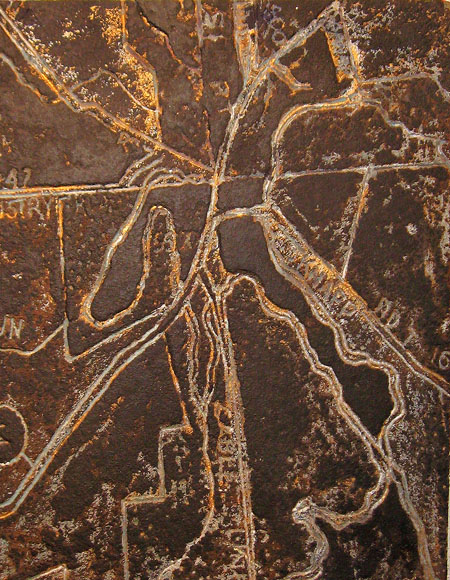
For a long time this image has sat on the bubble – that is to say, it has occupied a corner of the studio and my mind. It has been either on its way to the scrap heap or onward to further attention. A brief description: this is of medium density particle board, incised with a router and depicting a portion of Akron, Ohio in the form of a map. It has been around for a few years and has undergone a number of changes in response to a variety of notions on my part. Prior to this iteration it had been painted red with mica glitter occupying the grooves. Pointless.
Those notions? A map is an abstraction that reorganizes and/or simplifies in a useful fashion. I have posited that one can create a new complexity from a map, retaining a sense of the facts on the ground while introducing something of the artist. I’m sure there are those for whom such a task would be easy. For me it has been a major problem. I have adopted a number of approaches- all bothersome to a degree. An example…
One approach has been to make the incised map into something of an artifact. This painting represents a section of the Cuyahoga Valley National Park south of Cleveland. Here one can find nomenclature and surveyed boundaries sharing a common treatment with natural and artificial features. The surface was then rubbed over to create a worn and rusted look. A little Oldenburgian. It doesn’t make much of a statement, however, except to perhaps allude to a recent glacial history.
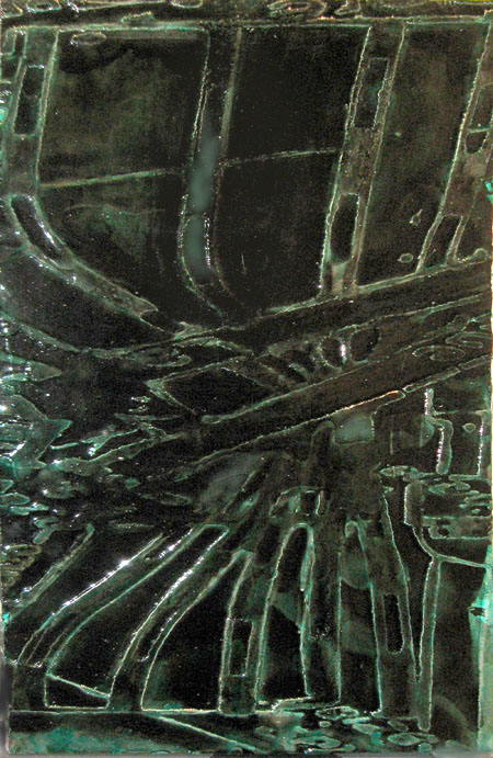
This example represents a train station in Paris and another in Rome butt-ended together: a short trip under a bridge from one city to the other. A cute little manipulation I must admit, but no appropriate treatment emerged. I finally resorted to giving it a celadon-over-black look using thick layers of drippy varnish.
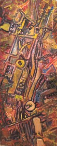
With the first example I have made reference to the jumble of shapes and colors that make up an urban area, and feel o.k. about doing so. Imagine that you have been assigned a map to paint. What would you do?
Finally, my apologies to those of you who object to bad photography. It’s been too cold and windy to go out and get a good shot.


Jay,
Troels, my geometer husband, loves your maps, in particular the first one. He started reminiscing driving along I-80, looking down on Akron.
Sitting in an airplane on a window seat, his eyes are glued to the landscape below.
My favorite are the train stations. Perhaps, because, as a child, I spent a great deal of time in them, not in Paris and Rome, but in Northern Germany, Bremen and Hamburg.
Birgit:
Geometer – what a great profession.
One sees the most wonderful things from a window seat. I’m particularly enamored of the transformations of perspective that occur at takeoff and landing: the gathering speed, the sound of the doors closing on the landing gear and the subsequent feeling of standing still in the air as the plane opts for altitude, and the shift as the approaching ground no longer reads as a kind of picture and becomes an environment into which one is falling.
And the views: coming into SEATAC with Mt. Rainier out one window and out the other an entire line of volcanoes stretching southward into California, or the swirling patterns on the Great Salt Lake, or the abundant geological unfolding of the western states. White out conditions always upset me, as though nature should not be intruding upon my education.
I believe there is a train with a title that runs between Paris and Rome, but I haven’t been able to find it.
Jay,
Your maps remind me of the Google images in Google Earth. I am still a total novice at using Google earth, and only downloaded the program in the last day or so, but even before that, I was fascinated by the terrain and satellite views you could see. ( I should be able to give you a URL, but now I’m unable to find anything but the downloaded program site; I know I’ve seen the satellite images without downloading, but I’m clueless how I did it).
I have started a thus-far rather bad painting, on silk attached to stretched canvas, using a Google Earth satellite image of that area of central north Oregon (the John Day Fossil Beds) with which I am fascinated. The satellite photo of the entire area, perhaps 100 miles square, is stunning. My painting is less so.
June:
Google Earth is one of those vast undertakings that comes to us free of charge and offers so much. I love to look in on places like the baikonur Cosmodrome and marvel at how junky the place looks from space, or the Lido with its endless ranks of beach umbrellas. Unfortunately Mount Desert Island in Maine, my favorite place, is shown in the most horrible resolution.
These paintings, however, are taken from a locally produced series of street and road maps that are totally linear and very plain Jane. In a number of instances I have distorted one of these map images using the perspective function in Photoshop, which produces the effect of looking across rather than down.
Imagine that you have been assigned a map to paint. What would you do?
BOLT
If bolting weren’t an option, then I suppose I would start thinking about a very old map with “here be dragons” warnings and clearly marked boundaries where you should be careful of falling off the edges, or a map of the ocean floor — done up as a Buddhist sand mandala. (In which circumstance, mica would be almost essential.)
Melanie:
As in Bolt, West Virginia? You already have a basic color scheme in the blue that Bolt is out of .
Sitting on the ocean floor making a mandala of Bolt, WV with mica would be worthy of a post. Keeping the mica from drifting off would be a feat in itself.
oh dear, i need a MAP to find BOLT. why-oh-why is it never simple. . . .?
Melanie:
Google Maps took me right to it – a fork in the road. Likely more useful the the Post Office than to anyone else.
Jay,
I love these both as maps and as abstract images. With your opening sentence I thought the first image was going to be the side of something in a meat locker. Is there by chance an Oscar Meyer plant somewhere about?
The black and steely colors of the last seem to fit the broad railyards one goes through slowly at the end or beginning of a journey. I was in various Gares and Termini often enough at one time, but I don’t recall going directly from one to the other. The Internet finds a Paris-Rome express called the Palatino. I don’t know about the return, but I’m guessing it’s called Montmartre or Garamond, depending on whether they’re more into geography or typography.
Even Bozeman has now been photographed by Google (or whoever provides the data), so one can now walk the streets and see the housefronts from anywhere in the world. You can’t see mine, though, the trees in front quite obscure it. Privacy retained.
Steve:
There you are!
A Boze-man will scoff at the sub-zero conditions that prompted my meat locker comment. But we around here tend to trade snow for cold, what with the lake and all.
So you never perchanced to go under the magic bridge. Maybe I could have a painting with two names: turned one way on the wall and it’s the Palatino, another and it’s the Garamond.